Geovariance

Example
Consider a data set that contains x-y coordinate information for the beginning points and ending points of transects (a sample dataset from Lake Champlain can be downloaded at this link xy.txt). The data are in comma delimited format with no column headers with northing location in column 1 and easting location in column 2.
There is a place for two data sets in the program, the first for setting up the area for estimation, the second for entering the beginning and ending points of each transect included. A rectangular area is constructed around the data input in the Area window for prediction. Note that this could be the transect information itself, in which case a rectangle is constructed around the existing transect data. But, alternatively, one can put in two - four points to roughly bound the area and let the program determine the maximum and minimum bounds.
Theory
Global variance estimates may be determined from each data set. These estimates are calculated as:
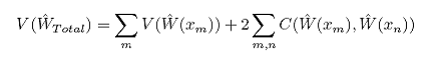
where:
 is the variance associated with each prediction at location xm as and
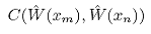 is the covariance between predictions at locations xm and xn and is calculated as:

where:
σ2 is the estimation variation,
λ is the vector of weights used in the predictions,
K is the spatial covariance between observation locations, and
k is the spatial covariance between observation locations and the prediction location